
Started: Beaufort Town Dock, 30°40.24′N 081°28.17′W, ICW mile 204
Anchored: Bonner Bay, 35°09.61′N 076°35.65′W, ICW mile 159
Log: 45 mi. Time: 8 hr. Engine: 4 hr.
The rain was real “wrath of God” rain. Not figuratively, but literally. Later, we found three frogs on Red Ranger. Like the story in Exodus, chapter 8, the rain included frogs. This was one of our most amazing days of sailing ever.

The wrath of God rain was a blinding storm. Again, we’re not talking figurative blinding; we’re talking literal blindness. We couldn’t see anything because the wind was blowing at over 30 miles per hour. The rain lashed at our faces: CA could look that way without risking injury because she had glasses. I squinted into the rain once.
The winds were sporty all day. Too sporty for folks like us. But, there we were. Sailing in what may have been a gale.
How was this day amazing? Let me count the ways.

Let’s begin with a 10:23 departure from Beaufort town docks. We chose slack tide, but the breeze was a challenge. The dockhands there helped us pivot around the end of the finger pier and launch out into Taylor creek without a serious problem.
Over the last two days, I had disgnosed the fuel tank sender problem. I changed the engine zinc and replaced the oil in the fuel injector pump. We’ve broken a fair number of things on Red Ranger. It’s amazing to have things in reasonably good working order.
We had a great motor up the Adam’s Creek Canal into Adam’s Creek. After five days at sea, and two days in town, the North Carolina country-side was a delight. We were amazed by trees, vacation homes, creeks and birds.
The Neuse
We expect problems in the Neuse River. We’ve never had a good passage of the Neuse. Today, the winds were forecast to be heavy — 20 knots of the S or SW — the kind of conditions that made a lot of people stay put in Beaufort.
Since we found a great anchorage in the South River (34°58.22′N 076°34.74′W, across the Neuse from Oriental, NC), we have two strategies for going N out of Beaufort.
- Duck in to South River if it’s crappy.
- Run the whole way to Bay River at the north if it’s less than crappy.
We don’t have a good set of strategies for going S. The problem here is that you have to get well out of Bay River to discover how bad the Neuse really is. By the time you’ve seen what you’re up against, you don’t want to turn back. Even though you should do.
Today, the wind was 20kt gusting to 25kt as we entered the Neuse. Depending on the direction of the wind, this is likely to be hellish. Turn back.
However.
Wind from the S (180°) is the perfect direction to push Red Ranger on a broad-reaching course of 060°: right up the river. We can’t emphasize that enough. The. Direction. Was. Perfect.
There are really three kinds of wind: too much, too little and the wrong direction. In this case, since the direction was perfect, it had to be too much wind.
We saw too much wind: 20kt gusting to 25kt is where fun sailing ends and serious wind starts. Those are wind speeds where reducing the sail area is essential.
At about 35kt the situation moves from serious amateur sailing to professionals only. Technically, this is a “Fresh Gale” on the Beaufort wind scale, level 8. Not really for the likes of us. Or so we thought.
At 41kt it’s a “Strong Gale” and no one wants that. At this level, it devolves to craziness trying to keep things from breaking.
We rolled out our smallest sail, the stays’l, turned off Mr. Leham, and cruised up the Neuse at a respectible 5 to 6 kts in blissful, amazing, pure sailing. The Neuse was heaped up into 3’ and 4’ seas with breaking waves. But, since we were running with wind and wave, it was delightful under our little scrap of sail.
Heading Up and Falling Off
Heading N on the Neuse, you have to round the Gum Thicket Shoal, Piney Point and the Maw Point Shoal. These shoals extend a mile and a half from shore. They’re marked by obscure, little dayboards. If you steer by the obvious lay of the land, you’ll plow straight into a shallow shoal.
The wind from the S had been building. To round Gum Thicket Shoal, we had to head up to a beam reach under just our little stays’l. By now, the wind was gusting into the 30’s. The tiny sail made us very happy. It also left us amazed that we could make a respectable 6 knots.
And we were amazed that we were handling wind of 30 gusting to 35 safely and sanely. We were having a great trip. We handled the boat competently. Nothing was flying about below decks. Neither of us got injured.
The good news was that we weren’t trying to prepare meals or sleep. That would have been awful. But we could comfortably loaf in the cockpit.
Once around Gum Thicket Shoal, we could take a turn away from the wind. After passing Piney Point, we could fall off even further. This put the wind back at 150°, which slowed us down to just 3 knots. Barely limping along in the big breeze that was available.
This isn’t unexpected. A sail slicing through the wind (beam reach or beat) generates a lot of power. A sail pushed by the wind (broad reach or run) doesn’t really do all that well at generating aerodynamic lift.
We unrolled the big yankee and speed jumped to 6 knots. For about half an hour.
Blinding Rain
As we entered the Bay River under yankee and nothing else, we realized that the hills ahead of us — Sander’s Point, specifically — were obscured by rain. And this wasn’t just “rain”: normal rain viewed from the water is some darkness under a rain cloud. This was a wall of fog. The water was dark. The clouds were dark. The space between was filled with a gray void we couldn’t penetrate.
The Commodore ordered all sails furled and Mr. Lehman started up.
This, it turns out, was amazingly brilliant.
About ten minutes after we got the yankee under control, the wind slammed us hard. It was gusting to 45 knots, pounding us with horizontal rain. If we’d had sails aloft, we probably would have been knocked nearly flat. Sideways in the water. Horrifying to contemplate.
As it was, we could see nothing. Rain hammered the dodger, rain filled the air. Rain slapped us in the face. I spent a tense 20 minutes staring only at the chart plotter hoping to get past the Green #3 dayboard in the Bay River.
Once we got into the Bay River, the worst of the storm had raced past. The wind subsided back into the 20’s and the rain let up enough that we could see where we were going. We put the hook down in Bonner Bay and cracked some beers to celebrate.

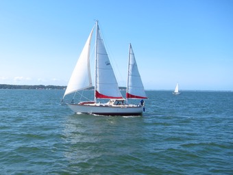
For three hours, the wind was flat. Nearly zero. See the picture above from just after sunset. Flat. By 21:00 it had picked up to 20kts again.
Today, we passed the Neuse, one of the big open water stretches here in North Carolina. Tomorrow promises to be a copy of today. With wind from the S again, we’ll tackle a short stretch of the Pamlico River, and the entire Pungo River, and drop the hook at the north end of the Pungo River.
Friday we can tackle the Alligator river, possibly parking in South Lake at the north end of the Alligator.
Saturday we may make Coinjock, NC. Then Great Bridge. Then Norfolk.